For those working at higher elevation offices, have you ever noticed surface features (e.g. lakes, rivers) in satellite imagery displaced slightly horizontally (lat/lon) from their designation in a placefile (a.k.a. from where they “should” be)? This is, in fact, normal behavior for satellite imagery. In brief, a satellite imager assumes a constant, low elevation across the viewing plane. When viewing the earth at an angle, therefore, higher elevation surfaces (and associated features) will be displaced a distance radially away from the satellite subpoint. The displacement of a given target will be a function of the elevation and distance from the satellite subpoint. The further away from the satellite subpoint and the greater the elevation, the greater the displacement will be. See figure 1 for details. The displacement is rarely more than a few km.

Figure 1: Graphical depiction of elevation displacement for three viewing scenarios. Full res
We analyze an example using GOES-16 visible imagery (Fig 2). A series of lakes across the southeast Colorado plains, elevation around 4,000 ft above sea level, are displaced a couple hundredths of a degree latitude and longitude north and west from the actual lat/lon location. The distance is slightly less than 1 km. From GOES-West (not shown), these features are displaced a similar distance to the north and east. In all examples below, lakes will appear dark gray, and solar farms will appear bright gray to white.

Figure 2: GOES-East visible imagery over southeast Colorado. Lake contours overlaid.
In the San Luis Valley, a high valley in southern Colorado, lakes and a solar array are displaced closer to 2 km from their actual position due to the higher elevation (~7,500 ft) and further distance from satellite subpoint (Fig 3).

Figure 3: GOES-East visible imagery over San Luis Valley, Colorado. Lake and Solar Farm contours overlaid.
Lakes in California, further west from the satellite subpoint but at lower elevation (1,000 ft – 1,500 ft), show very little displacement (Fig 4).
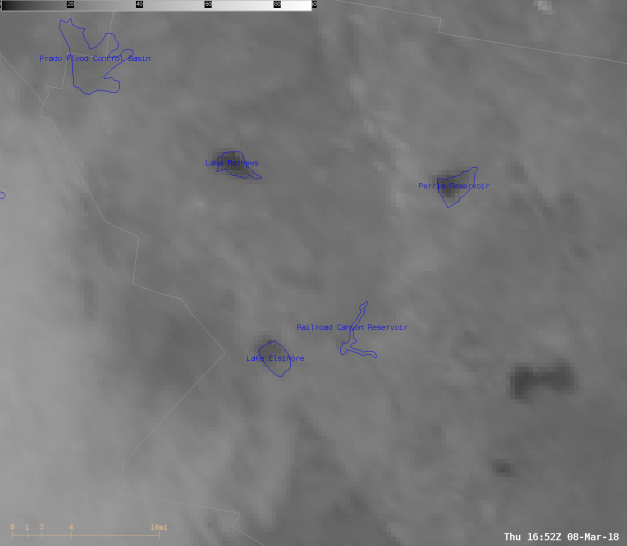
Figure 4: GOES-East visible imagery over southern California. Lake contours overlaid.
Lakes in Florida, closer to the satellite subpoint and at around sea level, have no apparent displacement from their actual location (Fig 5).

Figure 5: GOES-East visible imagery over Florida. Lake contours overlaid.
Comparing GOES-East and GOES-West using Bear Lake, ID/UT at around 6,000 ft as a high elevation landmark, the horizontal shift is quite obvious (Fig 6). From GOES-East, the lake (and surrounding terrain features), are shifted considerably to the north and west of the actual lake location. From GOES-West, the lake (and surrounding terrain features), are shifted similarly to the north and east of the actual lake location. Disclaimer: navigation issues with GOES-15 (current GOES-West) causes the image to bounce around. A time was chosen when the ocean coastlines appeared closest to accurate.

Figure 6: 10 March 2018 GOES-16 (East) and GOES-15 (West) visible satellite imagery at 1617 UTC and 1615 UTC, respectively. Full res
The displacement may be relatively small, but is an important consideration for high elevation offices when completing tasks that identify the precise lat/lon of a surface feature. One example of such a task is the identification of a wildfire hot spot, and subsequent notification (with lat/lon of hot spot) to partners. High elevation Rocky Mountain offices completing such a task should consider placing their hot spot “point” identifier on the southeast part, or just to the southeast, of the hottest pixels in the hot spot when using GOES-East imagery for detection.
Bill Line (NWS) and Eric Guillot (NWS)
