A warm, moist air mass in conjunction with a stationary front sparked severe weather on June 5, 2024, throughout Maryland, leading to 20 tornado reports and over six inches of rain. The 2100 UTC 05 June 2024 Weather Prediction Center (WPC) Surface Analysis showed dew points above 70F near the Mason-Dixon line along a stationary front, providing plenty of fuel for developing storms.

Storm Prediction Center (SPC) mesoanalysis at 2200 UTC 05 June 2024 showed Significant Tornado Parameter (eff layer) values approaching 1 just south of Washington, D.C. Significant tornadoes (EF-2 or stronger) are often associated with values greater than 1 within an hour of the tornado occurring.

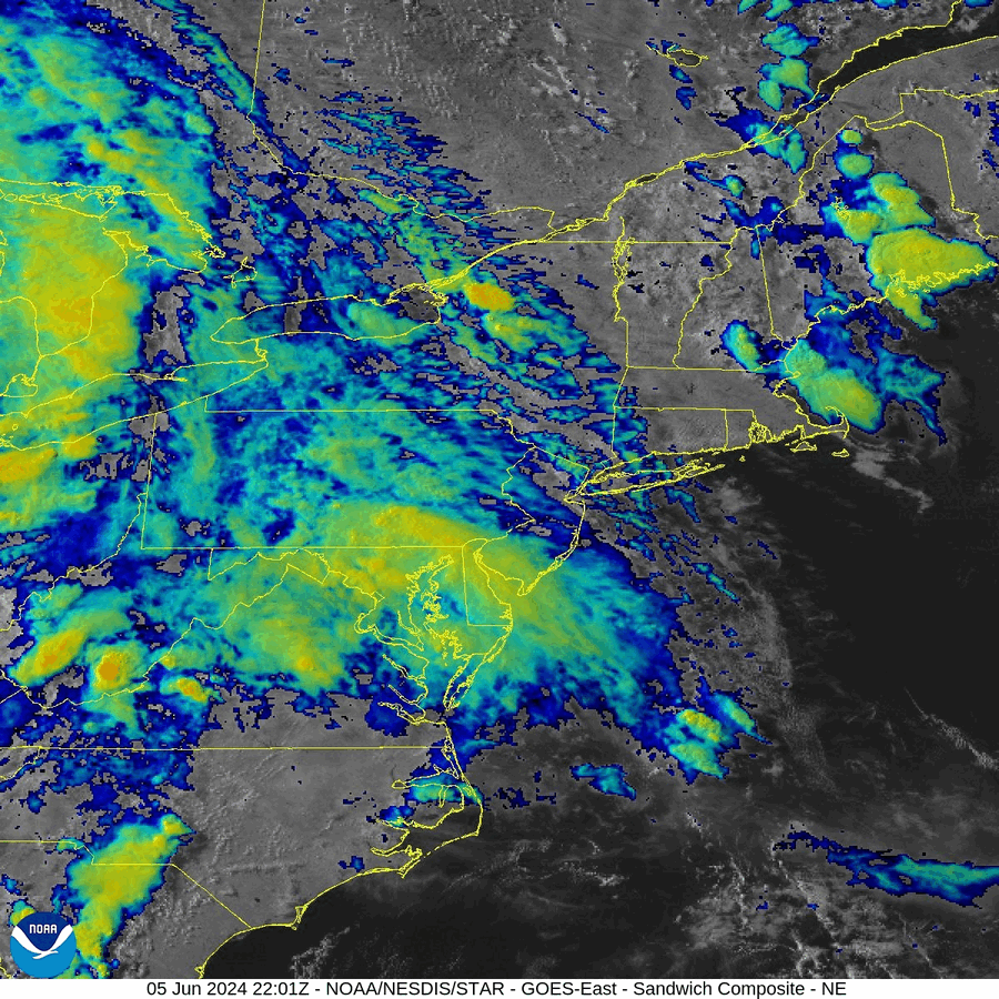
Indeed, about an hour later, GOES-East GLM Flash Extent Density (FED) overlaid on GeoColor showed storms fired across the state of Maryland, with two discrete convective cores visible. One of these storms was responsible for spawning a tornado that crossed Interstate 95 near Baltimore at 0045 UTC 06 June 2024.

The GOES-East Sandwich RGB also showed the explosive storms pushing east. The Sandwich RGB allows for the monitoring of severe storms by combining the high-resolution Visible band 3 (0.86 micron channel) with cloud top temperature information from the Clean IR Longwave Window band (10.3 micron).
The Experimental OCTANE Cloud-Top Cooling and Divergence Product, relying on 1-minute GOES-East mesoscale sector imagery, shows with great detail a tornado-producing storm northwest of Washington, D.C., from ~2300 UTC 05 June to ~0000 UTC 06 June 2024. Hotter colors represent cloud-top cooling derived from the GOES-East Clean IR Longwave Window band, while cooler colors represent horizontal divergence from optical flow derived from the Visible band during the day and the Clean IR Longwave Window band at night. The video shows the transition from relying on 0.5 km visible imagery (Solar Zenith Angle < 80°) during the day to 2.0 km IR imagery at night.
NCEI’s Weather Radar Archive showed the tornado-producing cell near Germantown, MD, at 2330 UTC 05 June 2024.

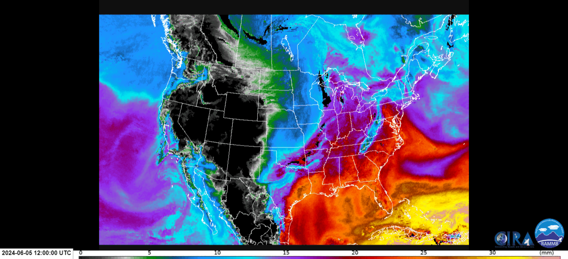
In addition to the threat from tornadoes, flooding was also a concern across the state of Maryland. From 1200 UTC 05 June to 0200 UTC 06 June 2024, CIRA Advected Layered Precipitable Water (ALPW) from the Surface to 850 mb showed precipitable water (PW) values approaching an inch being advected northward across much of the Mid-Atlantic.
The WPC Metwatch team issued a Mesoscale Precipitation Discussion (MPD) at 1736 UTC on 05 June 2024: “Deeper layer moisture through the Carolinas and through Virginia had brought overall Total PWats well above 1.75″ in the lower terrain starting to near 2″; while areas of eastern slopes of the Appalachians are slowly rising from 1.5 to the 1.75″ range or about 2 to 2.5 std dev from normal at this time of year.”

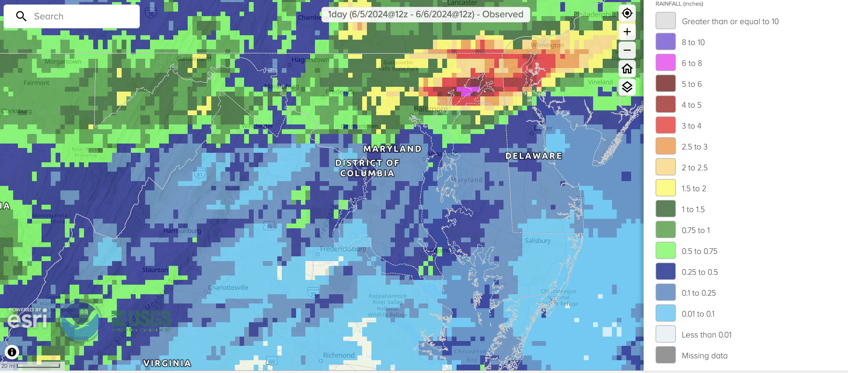
Training thunderstorms over the next several hours led to over 6″ of rain to fall in northeast Maryland, closing roads near Aberdeen, MD.
The Experimental OCTANE Cloud-Top Cooling and Divergence Product was evaluated at the GOES-R and JPSS Proving Ground Demonstration: Hazardous Weather Testbed – 2024 Spring Experiment, and a formal report will be released later this year.
Chris Smith, CISESS GOES-R Satellite Liaison for NWS WPC/OPC
